As biodiversity loss accelerates and endangered species face mounting threats, conservationists are increasingly turning to technology for innovative solutions. Drones, once primarily used for aerial photography, have developed into vital tools for monitoring wildlife, deterring illegal activities and assessing ecosystem health. When combined with artificial intelligence (AI), these technologies enable real-time data analysis, enhancing the effectiveness of conservation efforts. Sonoran Desert Institute (SDI), accredited by the Distance Education Accrediting Commission (DEAC), offers programs that provide students with foundational knowledge in Uncrewed Aircraft Systems (UAS). Through courses in drone design, flight testing and sensor integration, students gain practical skills applicable to various industries, including conservation. By equipping students with a strong understanding of UAS operations, the institute enables them to contribute to the advancement of conservation technologies, aligning with the growing demand for innovative solutions in environmental stewardship.
From tracking elusive animals to catching poachers in the act, drones are giving conservationists a critical edge. Their ability to cover vast terrains quickly, quietly and cost-effectively makes them ideal for missions that would otherwise be too risky, expensive or logistically complex.
Eyes in the Sky: Monitoring Endangered Species
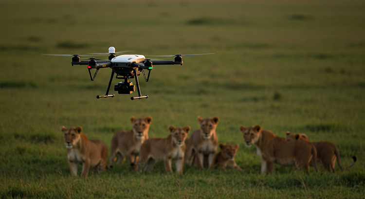
Conservation work has historically relied on ground teams and satellite imagery to track animal populations and habitat changes. While useful, these methods are often time-consuming and lack the real-time insight needed to respond swiftly to threats. Drones fill this gap by offering high-resolution aerial views that allow for continuous observation of species in their natural habitats without disturbing them.
Equipped with cameras, infrared sensors and GPS tracking, drones can follow herds of elephants across African savannas, monitor nesting sites of sea turtles or observe mountain gorillas in dense forests. These aerial tools make it easier to conduct population counts, identify habitat degradation and detect behavioral changes over time.
Drones are especially valuable for locating elusive or nocturnal species. Thermal imaging allows for nighttime tracking, helping researchers document movement patterns that were previously difficult or impossible to capture. This information is critical in creating effective conservation strategies and in managing protected areas more efficiently.
Stopping Poachers and Preventing Deforestation
Beyond monitoring wildlife, drones play a crucial role in anti-poaching operations and forest conservation. Illegal hunting and logging continue to pose serious threats to endangered species and their habitats. In many regions, human patrols are stretched thin, leaving vast swaths of land unguarded.
Drones equipped with live video feeds and thermal sensors can patrol these vulnerable areas day and night, covering more ground than foot patrols ever could. In real-time, they can detect human movement where none should be, identify potential threats and alert rangers for immediate response. It improves enforcement but also enhances the safety of rangers by reducing the need for dangerous confrontations.
In Amazon and Southeast Asia, drones are also being used to detect illegal deforestation, mapping clearings and identify logging activity that satellites might miss due to cloud cover or delays in image updates. These rapid assessments allow governments and conservation groups to intervene before irreversible damage is done.
By increasing the visibility of protected zones, drones serve as both a deterrent and a rapid-response tool, protecting endangered wildlife and the environments they depend on.
AI-Powered Drones and Ecosystem Analytics
Artificial intelligence is making drones even more powerful in conservation. By processing large volumes of aerial data, AI algorithms can automatically identify species, map their locations and track migration routes with minimal human input.
For example, AI can analyze patterns in drone imagery to determine where animals are congregating, which areas they are avoiding and how their behavior changes seasonally or in response to environmental stressors. It helps scientists understand the broader ecosystem dynamics and anticipate challenges such as habitat fragmentation, water scarcity or human-wildlife conflict.
AI is also being used to count animals in complex environments like coral reefs, wetlands or dense forest canopies. Image recognition software scans drone footage to identify specific species, estimate numbers and monitor population trends, offering a scalable solution to long-term data collection and biodiversity tracking.
These capabilities allow conservation programs to become more data-driven and precise. Instead of broad strategies based on limited fieldwork, organizations can tailor interventions to specific regions, species or threats, improving overall impact and efficiency.
Drones in Action
Around the world, drone technology is proving its worth in active conservation projects.
In South Africa, drones have become a frontline defense in the fight against rhino poaching. Using thermal imaging, conservationists monitor rhino herds at night and track intruders in real-time. The combination of drone surveillance and rapid ranger deployment has led to a notable decline in illegal hunting within some reserves.
In Indonesia, drones are used to map orangutan habitats and monitor palm oil deforestation. Conservationists rely on drone footage to identify critical nesting trees and ensure buffer zones are maintained between plantations and protected habitats. It has been key to forming sustainable land-use agreements with local governments and industries.
In the Galápagos Islands, drones have helped count sea lions, seabirds and marine iguanas, providing accurate census data with minimal environmental impact. These aerial surveys allow scientists to track changes in population health and adapt conservation plans to reflect evolving conditions.
Even in the United States, drones are being used to monitor monarch butterfly migration, assess prairie ecosystems and protect endangered desert tortoises by identifying habitat degradation from development projects.
Each success story demonstrates how drone technology is no longer just a tool but a vital asset in preserving the planet’s most vulnerable species.
The Path Ahead for Conservation Technology
As drone hardware becomes more affordable and AI algorithms more sophisticated, conservationists can continue to push the boundaries of what is possible. Future developments may include:
- Swarm drone technology that allows multiple drones to coordinate large-area surveys in less time.
- Edge computing enables drones to process data onboard and transmit only critical information.
- Integration with satellite data and Internet of Things (IoT) devices for real-time ecosystem health dashboards.
These innovations can make wildlife protection more proactive than reactive, enabling faster intervention and a more holistic understanding of the planet’s fragile ecosystems.
Education and training can also be crucial. As the demand for drone operators and environmental technologists grows, institutions can prepare students to work at the intersection of conservation and technology.
Sonoran Desert Institute recognizes the vital intersection of drone technology, artificial intelligence (AI) and field operations in addressing global conservation challenges. Through a curriculum that emphasizes real-world applications, students gain practical skills in UAS, including drone design, flight testing and sensor integration. This hands-on training equips graduates to play an active role in emerging conservation efforts, where technologies like drones and AI are increasingly used for wildlife protection, environmental monitoring and data analysis, fostering a more sustainable future.
Drones are not just flying cameras; they are guardians in the sky, enabling us to protect endangered species with precision, insight and speed. As the threats to biodiversity grow more complex, drone technology provides a beacon of hope for conservationists seeking to defend what remains.